


Pieve Torina: Things to See and Do
Pieve Torina is a town of about 1,200 inhabitants in the province of Macerata, in the Marche region. It lies at about 470 meters above sea level, at the gateway to the national park of the Sibillini Mountains. The village stands where two streams meet on their way down to the upper Chienti. One of them, the Sant'Angelo, runs through the town and, heading upstream, follows a narrow valley of small waterfalls, moss, old bridges and a medieval mill. Many of the reasons to visit Pieve Torina are linked to water: the Percorso delle Acque toward the hamlet of Fiume, the Kneipp path to walk barefoot and the Eremo dei Santi hermitage, which overlooks the narrowest part of the valley.
The area has been inhabited for a long time. Remains of a Bronze Age village have been found nearby. The area was populated by the Umbri as early as the 7th century BC and was colonized by Rome in the 3rd century BC. The village, reborn in the Middle Ages, was a fief of Camerino until it passed to the Papal States in the 16th century. On October 26 and 30, 2016, two strong earthquakes, of magnitude 5.9 and 6.5, almost completely destroyed the center and left many religious and civic buildings unusable. Reconstruction is still underway. The square has been rebuilt and the Museum of Our Land reopened in January 2025. For the municipal theater, demolished for safety reasons, the reconstruction project was approved in November 2025.
At a glance
- Municipality
- Pieve Torina
- Province
- Macerata
- Region
- Le Marche
On the map
Points from the site database. Map © OpenStreetMap contributors · Protomaps.
What to see in Pieve Torina
In Pieve Torina a visit focuses on three places: the Museo della Nostra Terra, the valley of the Sant'Angelo stream with the Fiume Mill in Pieve Torina and the Eremo dei Santi, and the area's churches, many of which were hit by the 2016 earthquake.
The Museo della Nostra Terra is in the Complesso di Sant'Agostino. The complex is medieval in origin, was founded by Augustinian friars and today includes the church, the museum and a retirement home. It is an ethnographic museum devoted to rural life: since 1976 it has kept over 5,000 objects from rural life in the Alto Maceratese, arranged in themed rooms. The collections came largely from donations by the residents of Pieve Torina and the surrounding area. The museum grew out of the first exhibitions organized in 1973 by Fernando Mattioni, who is considered its founder. After repair work following the earthquake it reopened on January 25, 2025. Besides guided tours of the collections, it now has an immersive room with archive footage and augmented reality headsets.
The town's religious heritage is extensive, but in many cases it was damaged by the earthquake. The parish church of Santa Maria Assunta, from 1722, was still destroyed in spring 2025 and reconstruction work had not started. The municipality also includes:
- the Romanesque pieve of Santa Maria, from the 11th century;
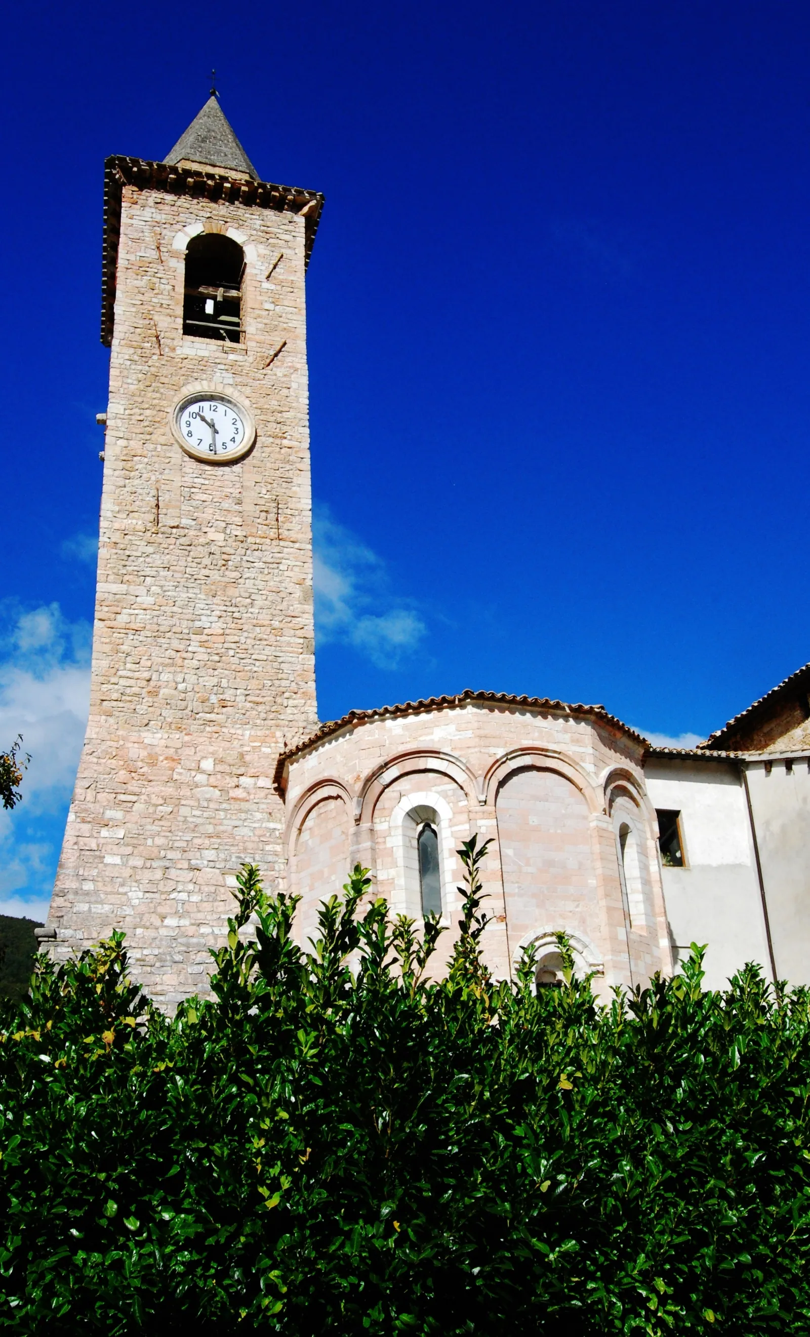
- the church of San Giovanni Battista, built between the 13th and 17th centuries, with a stone facade and a large apse: since 1985 it has housed the art gallery, with works such as a canvas by De Magistris and 14th-century frescoes detached from the pieve; since the 2016 earthquake it is best to check whether it can be visited;
- the church of San Michele, from the 13th-16th centuries;
- the sanctuary of Santa Maria di Caspriano, built in the 16th century in white stone on an octagonal plan, in an area of scenic interest, with a fresco of the Madonna from 1415;
- the castle of Capriglia.
Many buildings have remained unusable since 2016, so before visiting it is worth checking whether individual buildings are accessible.
The Eremo di Sant'Angelo in Prefoglio, also called the Eremo dei Santi, lies at about 690 meters above sea level, in the narrowest part of the Sant'Angelo valley, along the road that climbs from Pieve Torina toward Colfiorito. According to tradition it was built over the cave where Saints Peter and Paul are said to have stopped. The natural cave continues behind the crypt for about 35 meters. In the past the hermitage controlled the transhumance route that came down the valley from the mountains. It was closed after the earthquake: in 2017 the bell tower and the retaining wall were damaged, and landslides had cut the access path.
Farther upstream, in the hamlet of Fiume, is the medieval mill. Built on a spur of rock straddling the Sant'Angelo stream, it has a small lake and little waterfalls on either side, is still working and can be visited. A little farther on, on another rocky spur, are the church of the Madonna del Prefoglio and the remains of the castle of the counts of Prefoglio, who sold it to the Comune of Camerino in 1252. For more on the individual monuments, see the page things to do in Pieve Torina.
Nature and trails near Pieve Torina
The best-known trail in Pieve Torina is the Percorso delle Acque, also called the Sentiero delle Acque (the Water Trail). It is an easy walking and cycling path, just over 4 kilometers one way, that climbs the valley of the Sant'Angelo stream from the town to the hamlet of Fiume. The path opened in 2020. It can be done on foot or by bike and even with a stroller, except for the stretch leading to the Eremo dei Santi. Along the way there are tables and benches for breaks, Roman-era bridges, small waterfalls and wooden boardwalks. At the end, in Fiume, is the medieval mill. Pieve Torina has a parking lot dedicated to the path. Comfortable shoes are all that is needed.
Since July 2023 the trail has also included a Kneipp path: a stretch of about 500 meters along the Sant'Angelo stream to be walked barefoot, over stones, wood and gravel, in contact with running water. In summer it is very popular.
Those who want to walk more can continue beyond Fiume to the church of the Madonna del Prefoglio. In this version the hike reaches about 10 kilometers, with about 300 meters of elevation gain and a duration of 3 to 4 hours. The difficulty remains low ("tourist" level on the CAI scale), and on some Sundays in September and October it is also offered with guides.
The municipality also has other cycle paths: the Croce di Vari path, a scenic route between Vari and Macereto, and the Lucciano path. The municipal territory includes many hamlets scattered across the slopes, including Fiume, Vari, Lucciano, Capriglia and Torricchio, at very different elevations between the valley floor and the peaks. For outings off the marked routes the usual rule applies: check the weather before setting out.
Where to stay in Pieve Torina
The Pieve Torina area has several places to stay, also useful as a base for visiting the Sant'Angelo valley and the Macerata side of the Sibillini. The full list is on the page where to stay in Pieve Torina.
Post-earthquake reconstruction is still underway and there are several building sites in town: it is worth keeping this in mind when choosing where to stay and checking availability before setting out.
Where to eat in Pieve Torina
In Pieve Torina and its hamlets there are a few places to stop for lunch or dinner, including before or after the walk along the Percorso delle Acque. The up-to-date list is on the page Pieve Torina restaurants.
Local food and crafts of Pieve Torina
Pieve Torina is known for pig and cattle farming and for its poultry farms. It is an economy tied to the land, the same one told by the collections of the Museo della Nostra Terra.
Among the town's most traditional activities is craftsmanship, especially wrought iron work, used to make everything from window grilles to statues.
Among the sweets is the Torinetta, a tart that reinterprets the classic ricotta and chocolate tart by adding local honey, walnuts and a touch of truffle. The name was given by the mayor of Pieve Torina, to underline the link between the tart and the town.
Weather and how to get to Pieve Torina
By car, Pieve Torina is reached from state road 77 of the Val di Chienti, which links Foligno to Civitanova Marche via the Colfiorito pass. From Macerata and the coast, take the SS77 toward Foligno and exit at Muccia, from where it is a few kilometers. From Rome and Umbria, take the SS3 Flaminia and then the SS77 toward Civitanova Marche. Pieve Torina is about 45 kilometers from Macerata and about 70 from Ancona, to the southwest. From the Colfiorito plateau it can also be reached by descending the Sant'Angelo valley, the road overlooked by the Eremo dei Santi.
The most convenient train stations are Macerata and Camerino-Castelraimondo. Local buses run from Macerata, Camerino and Castelraimondo to Pieve Torina, more often on weekdays than on holidays. The nearest airport is Ancona Falconara, about 90 kilometers away. Farther away are the airports of Perugia, about 110 kilometers, and Pescara, about 160.
For the weather, elevation matters: the town is at about 470 meters, but the hamlets and peaks of the municipality rise much higher, so conditions can change a lot between the valley floor and the slopes. Before setting out, especially in winter and for hikes, it is worth checking local forecasts and road conditions. Pieve Torina is one of the villages covered in the section Sibillini Mountains villages.
In this section
3 results
 Things to Do in Pieve Torina15 places
 Where to Stay in Pieve Torina7 places to stay
 Pieve Torina restaurants4 places
No results with these filters.