


Preci: what to see and do
At a glance
- Municipality
- Preci
- Province
- Perugia
- Region
- Umbria
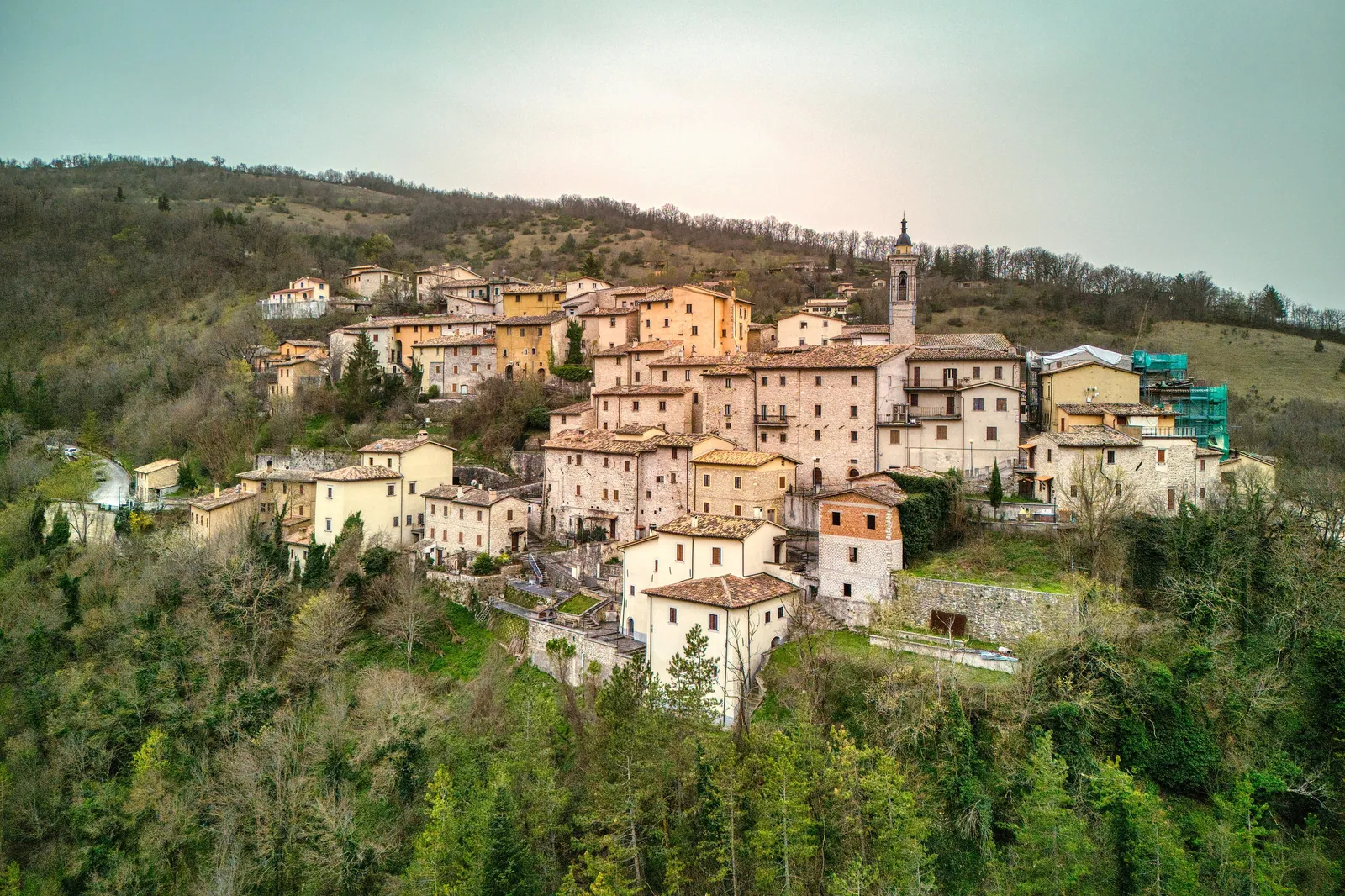
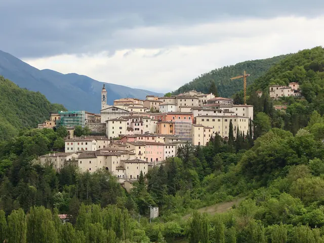
Preci is a village in the upper Valnerina, in the province of Perugia. It stands on a hill at 596 meters above sea level, above the Valle Castoriana, inside the Sibillini National Park (Monti Sibillini). The name comes from the Latin preces, "prayers". The first document mentioning the village dates from 1232 and refers to a small castle that grew up around a Benedictine oratory. The earthquake of 1328 destroyed it almost completely. During the rebuilding Preci took on the 16th-century look that sets it apart, with many small noble palaces built from the 16th century onward, and today it belongs to the Borghi più belli d'Italia (Most Beautiful Villages in Italy). It became a municipality in 1817.
The name of Preci is linked above all to medicine. Between the late Middle Ages and the early modern period, the Preci surgeons, trained around the Abbey of Sant'Eutizio, were known for removing stones and for eye operations. Anyone planning a visit should know one thing: the tremors of October 26 and 30, 2016 badly damaged the abbey and made the historic center completely unusable. Reconstruction is still under way. For this reason, a visit today focuses on the surrounding area: the hamlets of the Valle Castoriana and the valle Oblita, the rural churches and the Park's trails. Other villages in the area are described on the page villages of the Sibillini Mountains.
On the map
Points from the site database. Map © OpenStreetMap contributors · Protomaps.
What to see in Preci
The Abbazia di Sant'Eutizio is the main monument of Preci and is being rebuilt. It lies in the Valle Castoriana, near the hamlet of Piedivalle. Its origins are told in the Dialogues of Saint Gregory the Great: in the 5th century the father Spes and a group of hermits founded an oratory dedicated to the Virgin, next to a spring that still flows today from a large travertine boulder. After Spes died, the community passed to his disciple Eutizio. The church has a facade with a double-arched portal and an inscription from 1190. The 17th-century bell tower, designed by the papal architect Crescenzi, stood on the cliff above the complex. In the same cliff are the caves where the hermits lived, among them Saint Eutizio and Saint Fiorenzo.
In the 2016 earthquake the bell tower collapsed and the cliff slid onto the monastery buildings. Work on the church began on December 14, 2022. In December 2025 the rose window was put back on the facade, reassembled from original fragments picked out of the rubble. The project covers the church, monastery, bell tower and cliff. The bell tower will be rebuilt in the same spot and with the same appearance as before, but with a new structure. In early 2026 the engineers expected to finish the church within the year and the monastery about a year later. Making the cliff safe, on the other hand, would take about three years. Before going, it is therefore best to check whether the abbey is open.
The Scuola chirurgica preciana (Preci school of surgery) grew up around the abbey. It had its golden age in the Val Castoriana between the late Middle Ages and the 16th century. The Benedictine monks taught their knowledge to the local people, who were already skilled at raising and butchering animals. This gave rise to a tradition of lay surgeons, sought after by the courts of France and Spain and by the hospitals of Rome and Florence. They were best known for cataract surgery and lithotomy, the surgical removal of stones.
In the historic center are the Church of Santa Maria della Pietà, dedicated to the patron saint, the church of Santa Caterina and the Palazzo Comunale (town hall). At the southern end of the village, the walls preserve the Arco di Finocchioli, an archway looking out over the Valle Castoriana. After 2016 the historic center was declared completely unusable. In March 2026 funding was granted for work on utilities, paving and retaining walls in the historic center and in the hamlets of Abeto, Todiano, Montaglioni and Piedivalle.
Many hamlets have notable works of art:
- Poggio di Croce, in the valle Oblita, has a pointed-arch gate with a bell tower. The church of Sant'Egidio has remains of 15th-century frescoes of the Marche school. The 14th-century church of the Annunziata holds the Annunciation by Giovanni del Biondo, the most important example of Florentine art in the area.
- Montebufo, at 1,016 meters, is the highest village in the valle Oblita. Its 16th-century church of San Leonardo di Limoges has two 15th-century portals. It was badly damaged by the 1997 earthquake and later looted.
- Valle began as a castle guarding the abbey and preserves the churches of San Fiorenzo (13th century) and San Macario (16th century).
- Piedivalle is the largest hamlet of the Guaita di Sant'Eutizio. The walls of the medieval castle can still be seen, while the churches are in poor condition after the earthquake.
Before going, it is best to find out which churches are open. More details are on the page things to do in Preci.
Nature and trails near Preci
The territory of Preci stretches from the southeastern part of the Sibillini National Park to the northern end of the Valnerina. Elevations range from 422 meters to the 1,493 meters of Monte Cavolese. Much of this area belongs to the European Natura 2000 network, with the Sites of Community Importance Valle Campiano and Valnerina. The heart of the municipality is the Valle Castoriana, which runs from Forca di Ancarano to Ponte Chiusita and is crossed by the Campiano stream, a tributary of the Nera. Hemp was once grown here in small fields called "canapine". In spring, many varieties of wild orchids grow along the valley's numerous trails.
Among the hikes, the Monte Moricone loop starts from the village and follows trail E12. It is a route of intermediate difficulty, taking just under five hours of walking. For a short walk there is the loop to the chapel of the Madonna dell'Icona, which takes about an hour.
The Val Castoriana is also good for mountain biking. A route from Preci to Monte Moricone is 21 km long with 950 meters of elevation gain and is recommended from May to October. In winter the valley is used for cross-country skiing and ski touring. After 2016 some routes in the area were declared impassable: check the condition of the chosen trail and the weather forecast in advance.
Where to stay in Preci
You can stay in the village or in the hamlets, which are also convenient for walking in the Val Castoriana and the valle Oblita. The available accommodation, with descriptions and services, is on the page where to stay in Preci. On holidays and summer weekends it is best to book ahead.
Where to eat in Preci
The cooking of Preci is based mainly on trout and prosciutto. Trout is tied to the valley's streams: in Corone, along the Campiano river, there is a fish farm for sport fishing. Prosciutto comes from the norcineria tradition (the art of pork butchery and curing). Norcia black truffle often appears in pasta dishes and meat dishes. Restaurants and trattorias are listed on the page Preci restaurants.
Local products of Preci
The most representative product of Preci is prosciutto di Norcia IGP. In the hamlet of Abeto there is a ham-curing plant belonging to the consortium. Pork butchery also produces salami, fresh and aged sausages, capocollo, and cured meats from fallow deer and wild boar. Among the cheeses, pecorino stands out, in versions with black truffle, aged in pits (di fossa), aged in caves (di grotta) and coated in ash. In the Montebufo area, farro dicocco, a particular variety of emmer wheat, is grown.
Prosciutto is also the star of Pane, Prosciutto & Fantasia, the early-summer festival dedicated to the culture of the Valle Castoriana. There are tastings, a market fair and demonstrations of old trades, such as cheese and bread making, basket weaving and blacksmithing. The shops are listed on the page Preci local products and shops.
Weather in Preci and how to get there
Preci falls within climate zone E, like many mountain towns in the Apennines, so winters are cold. In eastern Umbria, the most mountainous part of the region, snow usually falls above 800 meters from the start of winter and, in some places, until April. The village is at 596 meters, but many hamlets are higher. Snow can fall even out of season: on May 16, 2026 snow covered Castelluccio di Norcia and the Montebufo area. In winter it is useful to check the forecast and road conditions.
By car from Rome, leave the A1 at Orte, continue on the Flaminia (SS3) toward Spoleto and then take state road 209 Valnerina. From Perugia it is about 100 km, on state roads 75, 3, 395 and 209. From the Adriatic coast, leave the A14 at Civitanova Marche, take the expressway toward Macerata and Tolentino and at Muccia turn off toward Visso and the Valnerina. The nearest train station is Spoleto. The most convenient airports are Perugia and Rome Fiumicino.
In this section
4 results
 Things to do in Preci6 places
 Where to stay in Preci15 places to stay
 Preci restaurants5 places
 Preci local products and shops3 places
No results with these filters.