


Castelsantangelo sul Nera: what to see and do
At a glance
- Municipality
- Castelsantangelo sul Nera
- Province
- Macerata
- Region
- Le Marche
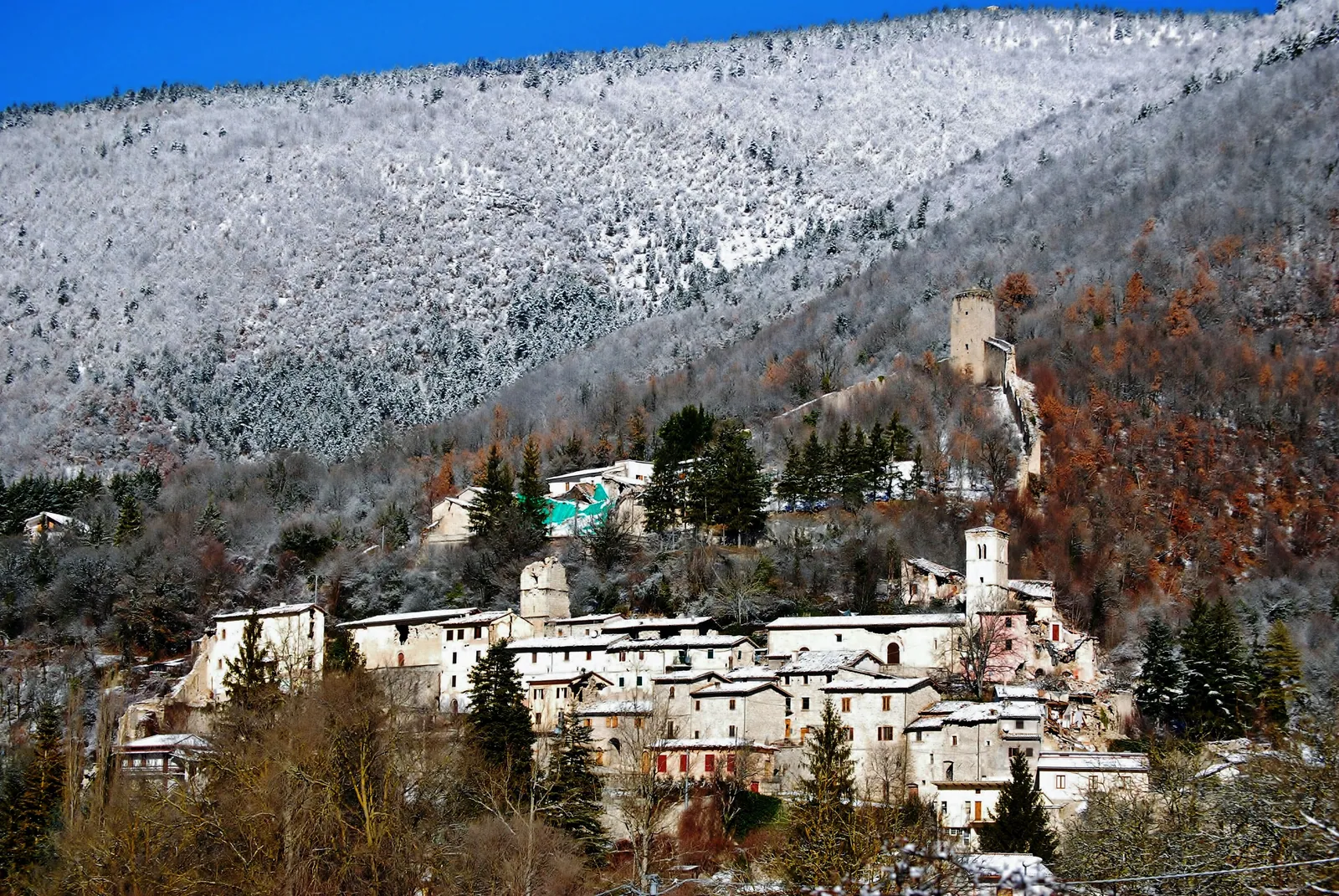
Castelsantangelo sul Nera is a municipality in the province of Macerata, on the border between the Marche and Umbria. The Nera river rises within its territory, and this is where the Valnerina begins. The village stands in the upper Nera valley, on the slope of Monte Cornaccione and facing the pyramid of Monte Cardosa, at the point where three valleys meet: Valle Infante, Valle di Rapegna and Valle di Corveto. The municipal building is at 731 meters above sea level. The municipal territory, which lies entirely within the Sibillini National Park in the Monti Sibillini, drops to 695 meters and rises to 2,250.
The castle, founded in the Middle Ages under the name Castrum Sancti Angeli, has a triangular plan: the watchtower stands at the apex and from there run the walls enclosing the historic center. Here the inhabitants fought against Norcia for the lands of Gualdo and the Pian Perduto, a war that ended on July 20, 1522 in Castelsantangelo's favor. The October 2016 earthquakes had their epicenter right in the municipality and nearly destroyed the main village and its hamlets. Today Castelsantangelo sul Nera is a village under reconstruction, surrounded by springs, beech woods and border plateaus.
On the map
Points from the site database. Map © OpenStreetMap contributors · Protomaps.
What to see in Castelsantangelo sul Nera
First of all, the historic center of Castelsantangelo sul Nera was devastated by the 2016 earthquake and reconstruction is still under way. There were three shocks: two of magnitude 5.4 and 5.9 on October 26 and one of magnitude 6.5 on October 30. Of the roughly 1,100 homes in the municipality, spread between the main village and six hamlets, 96% were damaged. In 2025 three projects were approved: the consolidation and restoration of the walls of the main village, the demolition and rebuilding of the town hall, and works against hydrogeological risk, on which the reconstruction of private homes depends. Before visiting it is worth finding out which parts of the village are accessible.
Before the earthquake the village preserved its 15th-century walls and street plan, with a square tower, the circuit of walls and the entrance gates. Its history is tied to Visso. In 1255 the last feudal lord, Tiboldo di Farolfo di Nocria, gave up his rights in favor of Visso in exchange for the office of podestà. From then on Castelsantangelo was the center of the Guaita Montanea, one of the administrative units of the free commune of Visso. Il Berettaccia, a shepherd-poet from the village who lived in the 17th century, told of the 1522 victory in a rhyming poem, «La battaglia del Pian Perduto». The village became an independent municipality under a law of 1913, applied only in 1920, and took its current name in 1970.
The religious heritage includes four churches: Santo Spirito, San Sebastiano, San Martino dei Gualdesi and Santo Stefano. San Sebastiano, in piazza del Ponte, dates from 1576. Santo Stefano has a Romanesque portal and a 14th-century stone baptismal font. There is also the monastery of San Liberatore. The hamlets too have churches important for local worship: in Macchie, for example, the church of San Giovanni overlooks the square and that of Sant'Antonio stands at the far end of the village.
The Ecomuseo del Cervo (Deer Ecomuseum) and the Centro faunistico (wildlife center) tell the story of the reintroduction of red deer into the Sibillini Park, but they are currently closed. The visitor center displays dioramas of the Park's typical habitats. The Centro faunistico is a fenced area of about 30 hectares in the Vallinfante area, near the source of the Nera, and was damaged by landslides caused by the earthquake. A repair project has been approved that includes rebuilding about 1,800 meters of fencing and replacing the aviaries.
The water museum, on the other hand, is an open-air route in nine stops. It begins at the source of the Nera and continues with an old water mill between Vallinfante and the main village, the aqueduct intake, a 20th-century hydroelectric plant, the bridge of the old Nocelleto sawmill and a trout farm, ending at the plant that bottles mineral water. The individual sites are described on the page on things to do in Castelsantangelo sul Nera.
Nature and trails near Castelsantangelo sul Nera
The springs of the Nera river are in the hamlet of Vallinfante and are the easiest starting point. A car can be driven up to a small parking lot with two drinking fountains. Around the springs there is a meadow, some picnic tables and the first stop of the water museum. About 100 liters of very cold water per second flow from the springs. Two legends were born here: according to the first, the water once came out of two cavities resembling an animal's nostrils; according to the other, Nera was a woodland nymph whom Juno turned into a river, and Velino throws itself off the cliff at Marmore to be reunited with her.
The best-known trail leads from Vallinfante to the Cascata del Pisciatore, a waterfall on a stream coming down from Monte Prata. Leave the car in the open area above the springs and walk along a road that is first paved and then gravel. The route passes the little church of the Madonna della Maina, also called Madonna delle Gee, goes past a barrier and enters the beech wood. Route details:
- length: about 3 km one way;
- time: about 2 hours round trip;
- difficulty: easy, also suitable for families;
- season: all year round.
The climb is steady but shaded, and the trail markers are stones laid out as arrows. It is also possible to start on foot from the main square of Castelsantangelo and walk up to Vallinfante along the paved road.
The Valle Infante is red deer territory: the animal was reintroduced here in the early 2000s, after centuries of absence. Higher up are the plateaus and border passes: the Pian Perduto at 1,345 meters, Forca di Gualdo at 1,496 meters and Fonte del Lupo at 1,775 meters. The Pian Perduto forms a single plateau with the Piani di Castelluccio, but unlike the Pian Grande and the Pian Piccolo, which belong to Norcia, it lies in the municipality of Castelsantangelo, in the Marche. From Castelsantangelo trails lead to the Pian Perduto, Monte Prata, Forca di Gualdo and the springs. On the border ridge stands the small sanctuary of the Madonna della Cona. Other points of interest are Monte Cardosa, the Monte Bove ridge and the Passo Cattivo cliff. The area can also be explored by mountain bike and on horseback.
On Monte Prata, at 1,850 meters, is the village ski area. It has a two-seater chairlift (Valle dell'Angelo-Monte Prata), a ski lift and a magic carpet for the ski school area, and serves runs of varying difficulty, from the Panoramica to the Canalone della Valle dell'Angelo. In the 2025-2026 winter the lifts stayed closed because of construction work: the Comune explained that the runs could not be used and that the parking lot was largely taken up by the works. Work is under way on a garage for the snow groomers and an underground pedestrian passage to the lifts. More information on snow in the area is on the page on the Frontignano di Ussita ski area. Before any high-altitude hike it is worth checking the weather.
Where to stay in Castelsantangelo sul Nera
Before the earthquake Castelsantangelo sul Nera was popular both in summer and in winter, thanks to its woods and the nearby ski lifts. Besides its roughly 300 residents, it had many vacationers with a second home in the village. The earthquake changed this picture and reconstruction is still under way. The properties that are open are listed on the page on where to stay in Castelsantangelo sul Nera.
Where to eat in Castelsantangelo sul Nera
The cooking of Castelsantangelo sul Nera is that of the pastoral mountains: dishes based on mushrooms, truffle, mutton and pork, made with local products found in the village's restaurants and shops. The eateries are listed on the page on Castelsantangelo sul Nera restaurants.
Local products of Castelsantangelo sul Nera
The local products of Castelsantangelo sul Nera come from the farming and pastoral tradition. For generations the main activity was livestock farming, especially sheep, and this is the origin of the aged cheeses, starting with pecorino. From the old custom of curing pork to face the long winters comes ciauscolo, a soft salami spread on bread.
Lentils, spelt and cicerchia (grass pea) have always been grown on the mountain land, along with roveja appenninica (a wild pea). On the nearby plateaus, on this side of the Sibillini, the Castelluccio lentil of Norcia PGI is produced. Water is also a local resource: near the springs of the Nera there is a plant that bottles mineral water.
Weather and how to get to Castelsantangelo sul Nera
Castelsantangelo sul Nera is reached by car via Visso, a few kilometers away.
- From the north and the Adriatic coast: A14 highway, exit at Civitanova Marche, then the SS77 toward Tolentino and Macerata, through Pieve Torina to Visso; from there follow the signs for Castelsantangelo.
- From Umbria: go up the Valnerina along the SS209 to Visso.
- From the south: take the SS4 Salaria, pass through Trisungo and Castelluccio and then follow the signs for Castelsantangelo.
By train, get off at Spoleto or, on the Marche side, at Macerata or Tolentino, and continue by regional bus. The most frequent connections are to Visso. The nearest airport is Ancona-Falconara, about 120 km away. Public transport schedules should be checked in advance, especially for the last mountain stretch.
The municipality is in climate zone E. In summer it offers cool air to those arriving from the Adriatic coast; spring and summer are the best seasons for hiking. In winter the mountain roads require care and snow tires are recommended. Monte Prata is known for its abundant natural snow, which usually allows skiing until late in the season. From Castelsantangelo it is also possible to drive to Castelluccio di Norcia, while the other villages of the area are described on the page on the villages of the Sibillini Mountains.
In this section
3 results
 Things to do in Castelsantangelo sul Nera22 places
 Where to stay in Castelsantangelo sul Nera3 places to stay
 Castelsantangelo sul Nera restaurants4 places
No results with these filters.