


Monte Bove Sud: how to get there and trails
At a glance
- Type
- Peak
- Municipality
- Ussita (MC)
- Elevation
- 2,169 m
Source: site database, © OpenStreetMap contributors (ODbL).
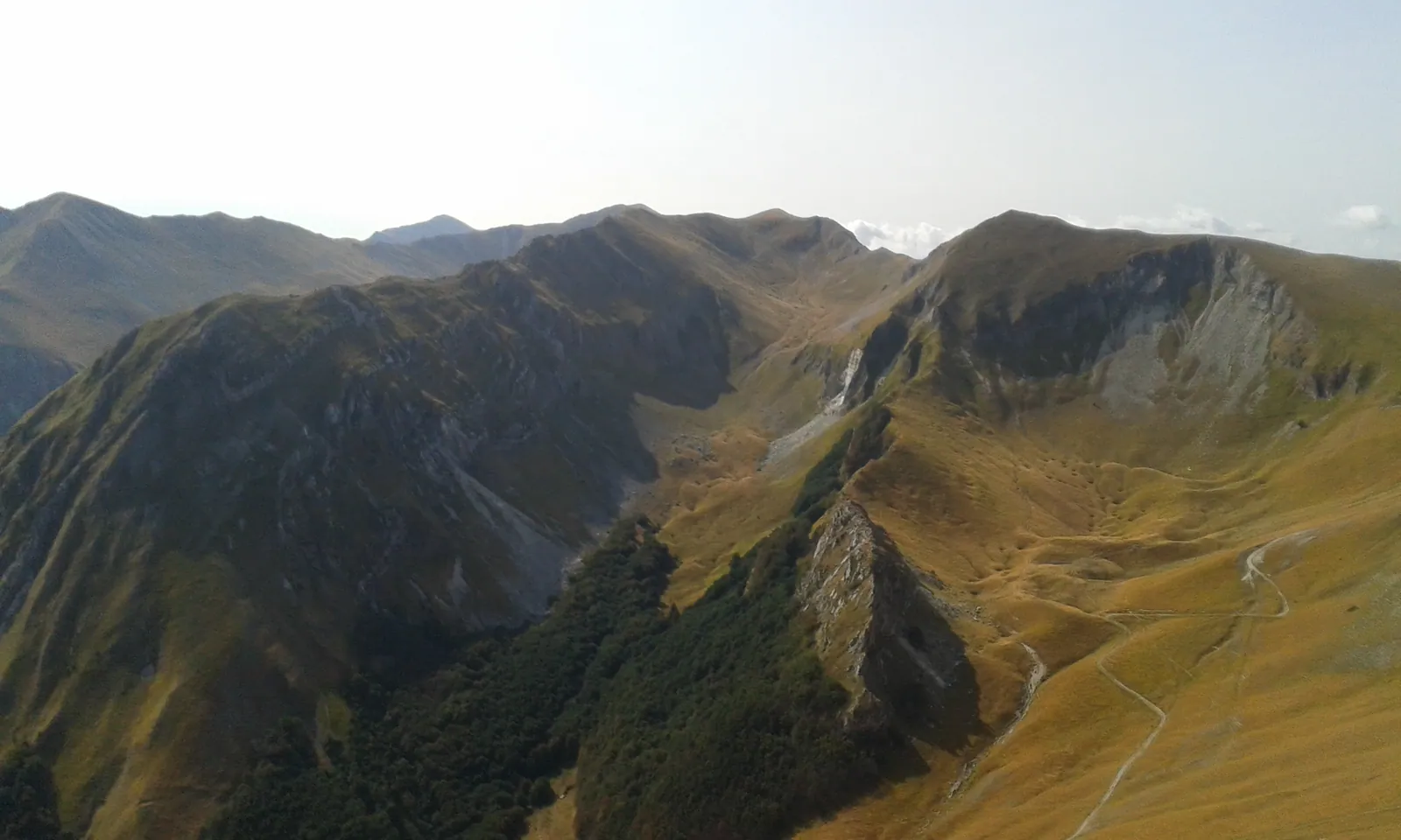
Monte Bove Sud rises to 2,169 m and lies in the municipality of Ussita, in the province of Macerata. It is the highest summit of the Monte Bove group, but it is very often considered a mountain in its own right. On the summit stands the upper station of an old cable car. The most popular ascent starts from Frontignano and follows the loop of trail E8 "Nel Regno del Camoscio" (In the realm of the chamois), graded EE (for experienced hikers).
The southern side overlooks the Val di Bove, a glacial cirque shaped by the Pleistocene glaciers. Here the Park has reintroduced the Apennine chamois. Until December 31, 2026, however, the route from Frontignano is closed even on foot under Ordinance no. 48 of August 25, 2026 of the Comune di Ussita, linked to the construction site of the Frontignano-Cornaccione gondola lift.
Before you go
Forecast
- Today10° / 6°0.0 mmCloudy
- Tomorrow11° / 6°7.3 mmLight rain
- Friday8° / 4°31.2 mmHeavy rain
Forecast by MET Norway, updated automatically · license CC BY 4.0
Rules and orders: Park website. Snow and avalanches: Meteomont bulletin.
On the map
Points from the site database. Map © OpenStreetMap contributors · Protomaps.
Where Monte Bove Sud is located
Monte Bove Sud is in the Sibillini National Park, in the Sibillini Mountains, within the municipal territory of Ussita. It forms the southern part of the Val di Bove. At its foot, to the south, lie the village of Macchie and the Vallinfante valley.
To the east the summit is linked to Pizzo Berro and the Priora. To the north the ridge continues toward Monte Bove Nord. For an overview of the other summits of the massif, see the page the peaks of the Sibillini Mountains.
How to get to Monte Bove Sud
The most used starting point is Frontignano, a hamlet of Ussita. From Visso, continue toward Ussita and then climb up to Frontignano. The E8 loop starts here. A second access to the E8 is the Cornaccione area, where the old chairlift used to arrive; it has been dismantled since 2025 for the construction site of the new gondola lift.
From Frontignano, following the Passo Cattivo dirt track, Cima Vallinfante can also be reached. Monte Bove Sud can be reached from Monte Cornaccione, the Passo Cattivo, Monte Bicco and Monte Bove Nord.
Access to Frontignano is currently affected by the works. An ordinance of the Comune di Ussita (no. 48 of August 25, 2026) bans vehicle and pedestrian traffic until December 31, 2026 for the works on the Frontignano-Cornaccione gondola lift. The ban also covers route E8. Before traveling, ask the Comune or the Park for information.
Trails and hikes on Monte Bove Sud
The main trail to Monte Bove Sud is the E8 "Nel Regno del Camoscio". The route is 14.4 km long, with 1,230 m of elevation gain and 5 hours and 10 minutes of walking from Frontignano. It can be walked in either direction. The route has two access points: the Cornaccione area, where the old chairlift used to arrive, and the hamlet of Frontignano. It takes in Monte Bove Sud, Monte Bove Nord and the Croce del Monte Bove, and uses trails 257, 272, 271 bis, 271 and 270. Until December 31, 2026 the route is subject to the ban on passage, even on foot, issued by the Comune di Ussita with Ordinance no. 48 of August 25, 2026 for the gondola lift construction site.
When it is open, the loop from Frontignano follows this route. It climbs the Saliere meadows to Pian dell'Arco-Belvedere and skirts the Cornaccione. It then reaches the top station of the chairlift, joins the E8 and climbs first to Monte Bicco and then to Monte Bove Sud. The descent runs through the Val di Bove, then along the Passaiola track to the Cristo delle Vette and finally down the gully to Frontignano.
A shorter alternative starts from the Rifugio Cristo delle Nevi, at 1,830 m, where the Selvapiana chairlift used to arrive. The trail heads toward Monte Bicco, at 2,052 m, without reaching its summit, and continues toward Monte Bove Sud. Check whether the lifts are running before counting on this option.
The ridge section requires care. The crest leading to Monte Bove Sud is narrow and suited to people who do not suffer from vertigo. In strong wind, double the caution on the ridge between the Bove Sud and Monte Bicco. As across the whole Park network, it is best to ask locally about the actual condition of the trails before setting out.
In winter the summit is also a mountaineering destination. From the Val di Panico a snow gully climbs up, reached on foot from Casali di Ussita, with slopes of up to 60° in the final stretch. It is a route for experienced mountaineers.
When to visit Monte Bove Sud
Monte Bove Sud is visited all year round, but conditions change a great deal. The Park states that the hiking trails can be walked from spring to fall. In winter the highest summits are covered in snow and are reached on skis.
The Park recommends particular care in the winter months and in early spring. Some trails reach heavily snow-covered summits, or cross gorges and valleys exposed to avalanches. For the high-altitude climb, hiking boots, suitable mountain clothing and a good supply of water are needed. It is also wise to check the weather the day before.
What to see near Monte Bove Sud
Other summits of the group lie along the ridge. To the north is Monte Bove Nord, while Monte Bicco is reached on the route toward the Cornaccione. The page on Monte Bove describes the entire massif.
On the western side, the Passo Cattivo, at 1,869 m, separates the Frontignano grasslands from the Tenna valley. Cima di Passo Cattivo and Cima di Vallinfante can be visited.
For a less demanding hike, there is the Val di Panico. It is a valley of glacial origin on the slopes of Monte Bove, walked while staying at lower altitudes.
Frequently asked questions
How high is Monte Bove Sud?
How many hours does the Monte Bove loop take?
Is the trail to Monte Bove Sud open?
Can you see chamois on Monte Bove?
Nearby
What to see nearby
- Fonte del LupoSpring800 m
- Monte BiccoPeak900 m
- 1.9 km
Where to stay
- Casale Monte Berro, UssitaBivouac or unstaffed hut1.4 km
- Casale Rinaldi, MontefortinoBivouac or unstaffed hut3.5 km
- Baita Gioiosa, UssitaTourist accommodation3.7 km
Where to eat
- Rifugio Saliere, UssitaRestaurant2.3 km
- Cotto e Mangiato, UssitaRestaurant3.0 km
- 4.3 km
Straight-line distances.