


Acquasanta Terme: things to see and do
Acquasanta Terme is a municipality in the province of Ascoli Piceno, in the upper Tronto valley, between the Sibillini Mountains to the north and the Monti della Laga to the south, less than 20 km from Ascoli along the Via Salaria. Its name comes from the sulfur springs that flow hot from underground. In Roman times the town was a mansio, a staging post, and it appears on the Tabula Peutingeriana under the name Vicus ad Aquas. Livy relates that in 50 BC the consul Lucius Munatius Plancus was cured by these waters after trying similar treatments in Tuscany without success.
The municipal territory of Acquasanta Terme is the largest in the province after that of Ascoli Piceno. It is mostly mountainous, has dozens of hamlets (some abandoned) and is covered with woods of chestnut, oak, beech and silver fir. The same karst processes that feed the springs gave rise to travertine, the stone quarried locally from which the historic centers of the Piceno area are built, starting with Ascoli. The main town lies at 392 m above sea level, and the municipality is part of the Gran Sasso and Monti della Laga National Park. There is plenty to do in Acquasanta Terme: bathing in free-access springs, Laga waterfalls, medieval churches and castles scattered among the hamlets.
At a glance
- Municipality
- Acquasanta Terme
- Province
- Ascoli Piceno
- Region
- Le Marche
On the map
Points from the site database. Map © OpenStreetMap contributors · Protomaps.
What to see in Acquasanta Terme
People come to Acquasanta Terme above all for the thermal waters, then for the churches of the main town and for the hamlets, home to castles, an abbey and the remains of Roman baths.
The baths have a long history. At first they were a natural cave in which the sulfur water collected before flowing down to the river; in 1780 a new spa building was built to a design by Lazzaro Giosaffatti. The water rises at the end of a series of caves: the first is used as a pool, the second as a sweating cave. The pool and the sweating cave, in the historic Art Nouveau complex, have been closed for more than thirty years; the modern spa building with the treatment areas is a separate facility, with opening periods to check before visiting. In March 2026 the relaunch project “Ritorno alle origini” (Back to the origins) was presented, aiming to reopen the pool, the sweating cave and the outdoor areas by 2027, with a spa and restaurant.
The springs can already be tried at Lu Vurghe, in the hamlet of Santa Maria. It is a free-access thermal spring, with sulfur water at about 30 °C collected in recently built pools. From the village a path leads down to the stream in about ten minutes. The path is steep and uneven and not suitable for strollers or wheelchairs. Also in Santa Maria are the ruins of the Roman baths, with a cistern and parts of the pools. In 1883 a terracotta jar holding about 275 Roman denarii was found here by chance.
In the main town are the 13th-century church of San Giovanni Battista, with an altarpiece by Cola dell'Amatrice, the 14th-century church of the Maddalena, and the Teatro dei Combattenti. Over the Garrafo stream, along the Salaria, stands a Roman bridge to which arches were added in the 19th century. After the 2016 earthquake the town saw many reconstruction sites: before setting out, it is worth checking which churches are accessible.
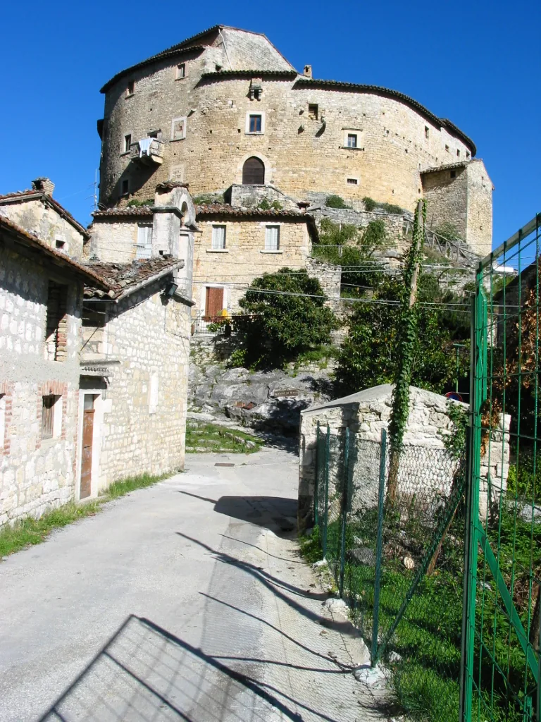
In the hamlet of Paggese is the 13th-century church of San Lorenzo, with a triptych by Pietro Alemanno; the local assembly once met in its loggia. Not far away, on a spur of travertine, stands Castel di Luco, an elliptical fortress. Badly damaged by the 2016 earthquake, it reopened in March 2024 after restoration and is a private historic residence. In Valledacqua is the 10th-century Farfa abbey of San Benedetto, with remains of frescoes. Other stops in the hamlets:
- the 16th-century bridge of Ponte d'Arli;
- the water mill of Piedicava;
- the house of the brigand Giovanni Piccioni in Rocca Monte Calvo: a former prior of Montecalvo, after Italian Unification he held out against the Piedmontese troops for a couple of years;
- the cemetery of the victims of the 1944 massacre, halfway between Pozza and Umito.
The pages on individual sites are gathered under things to do in Acquasanta Terme.
Nature and trails near Acquasanta Terme
The best-known hike near Acquasanta Terme leads to the Prata and Volpara waterfalls, on the Marche side of the Monti della Laga. It starts from the hamlet of Umito, known for its centuries-old chestnut trees. Park in the small area at the end of the village and follow a dirt road through well-kept chestnut groves, along the Rio Prata.
The Cascata della Prata, a drop of about 50 meters, takes about an hour on foot from Umito. The first part is easy. The last part climbs more steeply, but it was recently improved with switchbacks, railings and about a hundred steps, and it ends right below the waterfall. The return is by the same route. To continue, go back to the main dirt road as far as a mountain hut and then climb the trail toward Cascata della Volpara. Here the stream drops in natural chutes and pools, at the foot of the steep northeast face of Monte Macera della Morte (2,073 m). From Umito it takes about two and a half hours. The difficulty is moderate, the route is almost always in the shade, and the recommended season runs from March to November.
The Forcella waterfalls frame an old mill. The area is also crossed by an old network of mule tracks, restored and waymarked, linking the villages of the municipality with mills, castles, abbeys and towns in neighboring Abruzzo. From Paggese, for example, a mule track leads to a view of Castel di Luco. Several trails can be ridden by mountain bike, and the area has hosted bike and trial races. In the mountains the weather changes quickly: before setting out, check the forecast and trail conditions.
Where to stay in Acquasanta Terme
In Acquasanta Terme you can stay in the main town or in the hamlets. The main town is convenient for Lu Vurghe and the Salaria, while the hamlets are closer to the Laga trails. The list of places is on the page where to stay in Acquasanta Terme.
Where to eat in Acquasanta Terme
The cooking of Acquasanta Terme follows the mountain's produce: chestnuts, mushrooms, truffles and cheeses from the Monti della Laga. Addresses are gathered on the page about Acquasanta Terme restaurants.
Local products of Acquasanta Terme
The product most closely tied to Acquasanta Terme is the marrone, a large sweet chestnut: the Marrone di Acquasanta Terme is on the national list of Traditional Agri-food Products (PAT). The Piceno area holds most of the chestnut groves of the Marche, spread between Acquasanta and a few neighboring municipalities. Several local chestnut varieties grow in the municipality's woods, such as Rustica, Gentile, Inserta and Pallante. The Tallacano variety takes its name from the hamlet of the same name. The chestnut flowers also yield a dark honey with an intense, slightly bitter taste.
The best time to taste them is the Festa d'Autunno (autumn festival) of mountain products, organized by the Pro Acquasanta and the municipality. The 55th edition takes place on October 17 and 18, 2026, with a market-fair of chestnuts, mushrooms, truffles and cheeses, crafts and folk events. The area is also known for travertine, suited both to building and to artistic work. Shops and producers are on the page about Acquasanta Terme local products.
Weather and how to get to Acquasanta Terme
Acquasanta Terme has a sub-Apennine climate. Winters are damp and fairly harsh, with snowfall and average temperatures between 0 and 2 °C. Summers are hot and sunny, with little rain. The municipal territory ranges from 242 m to over 2,000 m above sea level, so on the Laga peaks conditions can be very different from those in the valley.
Acquasanta Terme is reached on the Strada Statale 4, the ancient Via Salaria: a single-carriageway road, but largely fast-flowing. In one direction it leads toward Amatrice, Rieti and Rome, in the other toward Ascoli Piceno and the Adriatic coast. Coming from Ascoli, the hamlet of Santa Maria, the starting point for Lu Vurghe, comes before the main town; you can park along the main road. For Umito, a provincial road leaves the Salaria at the edge of Acquasanta.
In this section
4 results
 Things to Do in Acquasanta Terme13 places
 Where to stay in Acquasanta Terme9 places to stay
 Acquasanta Terme Restaurants10 places
- Acquasanta Terme Local Products and Food Shops4 places
No results with these filters.