


Grande Anello dei Sibillini: the Loop Trek Around the Sibillini Mountains
The Grande Anello dei Sibillini (Great Sibillini Loop) is a hiking route of about 124 km that makes a complete circuit of the Sibillini Mountains range, between the Marche and Umbria. It has nine stages and is fully waymarked. It starts from Visso, where the National Park has its headquarters, and proceeds clockwise. It crosses the provinces of Macerata, Fermo, Ascoli Piceno and Perugia.
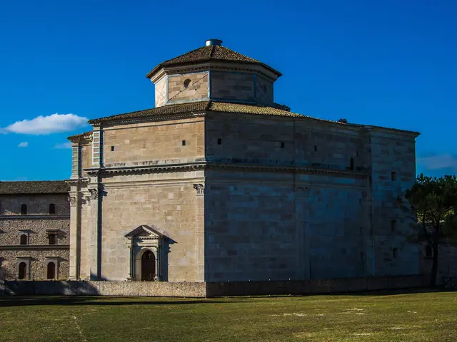
The route stays at the foot of the main ridge, never going above the 1,794 m of Forca di Giuda, and never climbs to the summits. Plateaus, beech woods, valleys, villages and isolated churches alternate along the way. The loop passes the octagonal sanctuary on the Macereto plateau, the grasslands of the Pian Grande and the view of Monte Vettore. After the 2016-17 earthquakes the loop can be walked with some variants. Some mountain huts have been replaced by temporary structures.
Before you go
Forecast at the start
- Today15° / 8°0.0 mmCloudy
Forecast by MET Norway, updated automatically · license CC BY 4.0
Rules and orders: Park website. Snow and avalanches: Meteomont bulletin.
The stages on the map
Map and track: © OpenStreetMap contributors (ODbL).
The stages
9 results
 Grande Anello dei Sibillini Stage 1Pieve Torina · Difficulty NON INDICATA · 12.9 km · +783 m · 5:05 h
- TrailGrande Anello dei Sibillini Stage 2Fiastra · Difficulty NON INDICATA · 11.0 km · +521 m · 4:35 h
- TrailGrande Anello dei Sibillini Stage 3Cessapalombo · Difficulty NON INDICATA · 9.7 km · +555 m · 4:10 h
- TrailGrande Anello dei Sibillini Stage 4Amandola · Difficulty NON INDICATA · 19.4 km · +965 m · 7:20 h
- TrailGrande Anello dei Sibillini Stage 5Amandola · Difficulty NON INDICATA · 11.0 km · +539 m · 4:25 h
- TrailGrande Anello dei Sibillini Stage 6Montefortino · Difficulty NON INDICATA · 14.0 km · +778 m · 5:25 h
- TrailGrande Anello dei Sibillini Stage 7Arquata del Tronto · Difficulty NON INDICATA · 18.4 km · +823 m · 6:20 h
- TrailGrande Anello dei Sibillini Stage 8Arquata del Tronto · Difficulty NON INDICATA · 20.2 km · +559 m · 7:10 h
- TrailGrande Anello dei Sibillini Stage 9Norcia · Difficulty NON INDICATA · 11.0 km · +408 m · 4:05 h
No results with these filters.
The stages of the Grande Anello dei Sibillini
The nine stages range from about 9 km to about 19.5 km. The durations given are walking times, without stops. The details of each section are on the dedicated pages, from Grande Anello dei Sibillini stage 1 to Grande Anello dei Sibillini stage 9.
Stage 1, Visso – Cupi. It is 12.1 km long, with 800 m of ascent and 432 m of descent, and takes 4-4.5 hours. The trail climbs the west slope of Monte Careschio to the pastures of the Macereto plateau. From there the octagonal sanctuary in Bramante style, an example of Renaissance architecture in the Marche, can be seen in the distance. The arrival in Cupi opens the view to the north, over the Umbria-Marche Apennines.
Stage 2, Cupi – Fiastra. It is 11.5 km long, with 495 m of ascent, and takes about 4 hours. The route climbs to the pastures and the ridge of Monte Coglia. After Pian del Capriolo it descends into a deep valley and crosses a dense reforested area, as far as the gravel road linking Fiastra to the Piani di Pao. The last section descends to Fiastra with fine views of the lake.
Stage 3, Fiastra – Monastero. It is 9.1 km long, with 518 m of ascent and 528 m of descent, and takes about 3 hours. Before descending through the downy oak woods toward Monastero (municipality of Cessapalombo), the Fiastrone gorge comes into view and, in the background, the Adriatic Sea.
Stage 4, Monastero – Garulla. This is the halfway stage: it is about 18 km long, with 863 m of ascent, and takes about 5 hours 50. It crosses the Ragnolo plateaus, known for their spring flowers. It then passes below the beech woods of Monte Valvasseto and crosses the Pintura pass. The descent into the Valle dei Tre Santi leads to Garulla, in the municipality of Amandola.
Stage 5, Garulla – Rubbiano. It is 9.7 km long, with 440 m of ascent and 510 m of descent, and takes about 3 hours 45. The walk follows a series of ups and downs through woods and small fields, in the Ambro and Tenna valleys.
Stage 6, Rubbiano – Colle. It is between about 12 and 14 km long, with about 800 m of ascent, and takes 4.5-5.5 hours. The route descends into the Aso valley, climbs back up to Altino and continues facing the long ridge that rises from Monte Banditello to Monte Vettore, 2,476 m high and the highest peak of the Sibillini. Across the Aso valley stands Monte Sibilla, 2,173 m, home to the grotta delle Fate (Fairies' Cave), linked to the mythical Apennine Sibyl. The stage ends at Colle di Montegallo.
Stage 7, Colle – Colle le Cese. It is about 18.6 km long, with 650 m of ascent, and takes about 5 hours. From Forca di Presta, continuing for about three kilometers, the route reaches the Belvedere along the Sentiero per Tutti NT2 (Trail for All). This section is also wheelchair accessible. In the distance lies Castelluccio, badly damaged by the 2016 earthquake and reachable by a variant.
Stage 8, Colle le Cese – Campi. It is about 19.5 km long, with 449 m of ascent and about 1,100 m of descent, and takes 6-6.5 hours. The walk crosses high-altitude grasslands and the Forca di Canapine ski area. From the edge of the Pian Grande, the Coste del Vettore rise in a single sweep of almost 1,200 m to the Cima del Redentore (2,449 m). The finish is at Campi Vecchio, a medieval village where the signs of the earthquake are still very evident.
Stage 9, Campi – Visso. It is 9.5 km long, with 345 m of ascent and 585 m of descent, and takes 3.5-4 hours. It follows the ancient road that for centuries linked Norcia to Visso. A pass at 1,200 m, between Monte Lungo and Monte Macchialunga, opens onto the basin of the Casali dell'Acquaro, one of the least visited areas of the Park. Here traditional farming is still based on lentils, wheat and fodder. The descent through the wooded valley closes the loop at Visso. The Park has reported works near the start at Campi Vecchio, which require a detour along the paved road toward Fonte Antica.
The route of the Grande Anello dei Sibillini
The classic itinerary starts from Visso, on the west side of the loop, and proceeds clockwise. It can also be walked in the opposite direction, starting from any of the stage points. There are many well-marked trail access points along the whole range.
The official map is published by the Parco Nazionale dei Monti Sibillini and allows each of the nine stages to be selected. It distinguishes trails that are open, those passable only with significant detours and those that are closed. Official GPX tracks can be downloaded for each stage.
After the 2016-17 earthquakes, the loop remains walkable thanks to small variants that bypass the restricted sections. These include historic centers that are still closed. In Visso and Campi, the red zones impose the short alternative routes.
The Park grades all stages T (tourist), but some basic fitness for mountain walking is needed. The elevation gain of the individual stages ranges from about 350 to about 860 m. Water deserves particular attention. Between Colle di Montegallo and Campi Vecchio the Park reports limited access to drinking water, so it is advisable to set out with a good supply.
There is also a bicycle version, on a route separate from the walking one. The Park offers a route for bikes, with many sections on provincial roads and asphalt. For walkers and expert mountain bikers there is a more demanding route.
How to plan the Grande Anello dei Sibillini
Completing the loop takes nine days of walking, one stage per day. The schedule is flexible, though: fit hikers can combine two or more stages, while others prefer to walk one section at a time on different occasions. For a weekend, the Park suggests choosing two consecutive stages.
The recommended period runs from May to September. The Ragnolo plateaus, along stage 4, are known for their spring flowers. Organized trekking tours include the Piani di Castelluccio during the flowering season, in July.
To reach Visso, the start and finish point, from Rome follow the A1 highway to Orte. Then take the E45 toward Terni and the SS209 Valnerina. From Ancona and the Adriatic coast, exit the A14 at Civitanova Marche and take the SS77 Val di Chienti toward Foligno. Exit at Muccia and continue toward Visso. Part of the historic center of Visso was closed after the earthquake, so the route includes detours.
In some sections the Grande Anello intertwines with the Cammino delle Terre Mutate. To compare it with other multi-day itineraries, see the page on multi-day hikes in the Sibillini.
Before setting out it is advisable to check the weather. It is also worth checking the Park website for the current status of each section, as variants and closures can change.
Where to stay along the Grande Anello dei Sibillini
Each stage point of the loop was designed with a mountain hut as a base, also reachable by car. The Park has renovated several hiking huts to improve the use of the route. However, the 2016 earthquake made some of these buildings unusable, and some have been replaced by temporary structures. For this reason it is advisable to check the status of each overnight stop in advance and book early.
In the organized trekking tours of recent years, nights have alternated between huts with half board, agriturismi (farm stays) and farm campsites. So there are also alternatives to the huts at several points along the route.