


Monte Priora: how to get there and trails
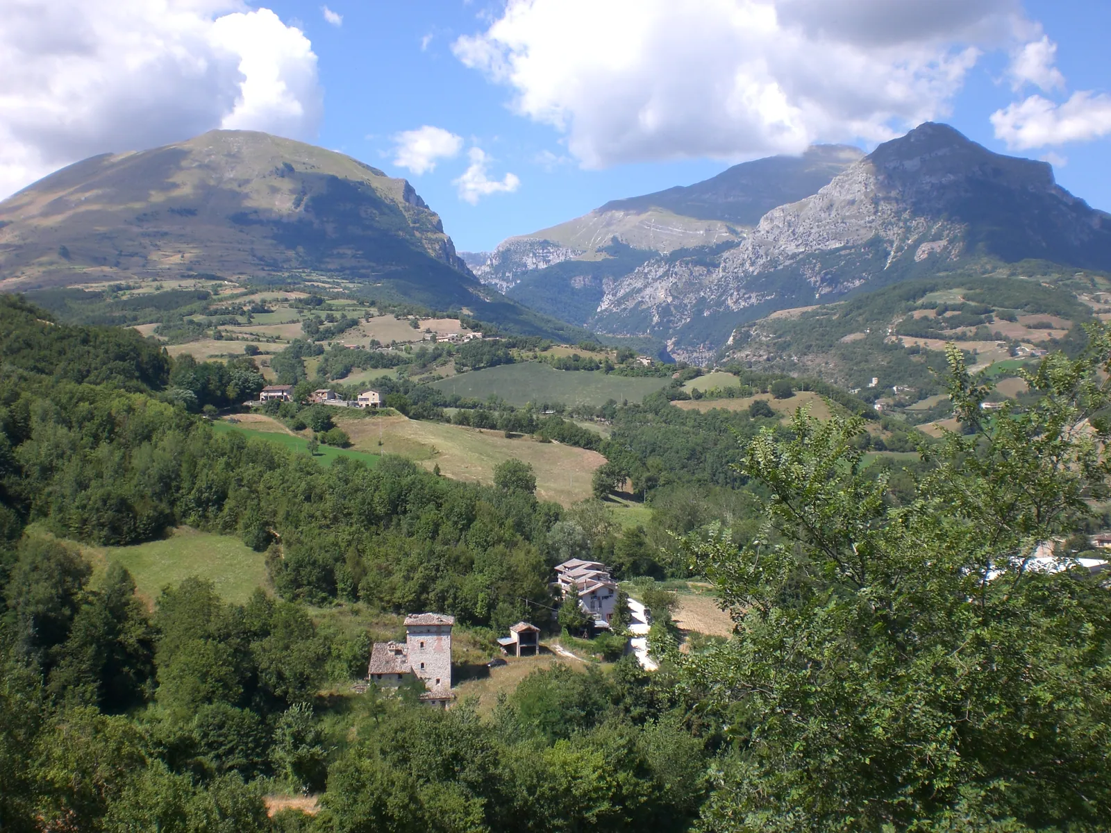
The Priora is the second-highest mountain of the Sibillini Mountains: Monte Priora, 2,332 m above sea level, is surpassed only by the Monte Vettore group. It lies in the municipality of Montefortino, in the province of Fermo, and since 1993 it has been under the control of the Sibillini National Park. It is also known as Pizzo della Regina, a name passed down orally and shown on IGM maps, whose origin is unknown. The other name, Monte del Priore, recalls the prior of the ancient Camaldolese hermitage of San Leonardo, which stands on its slopes.
The mountain is pyramid-shaped, with three ridges. It is made of limestone, and on the north side, below the summit, layers of maiolica limestone with its typical red-pink color crop out. The most popular ascent starts from the Forcella del Fargno, at 1,811 m, and takes about 6 hours out and back.
Before you go
Forecast
- Today5° / 0°0.3 mmCloudy
Forecast by MET Norway, updated automatically · license CC BY 4.0
Rules and orders: Park website. Snow and avalanches: Meteomont bulletin.
On the map
Points from the site database. Map © OpenStreetMap contributors · Protomaps.
Where Monte Priora is located
Monte Priora lies on the Adriatic side of the Apennine watershed, in the northern part of the Sibillini. To the north it is bounded by the Valle dell'Ambro, which separates it from the Castel Manardo massif and Pizzo Tre Vescovi. To the south, the Tenna gorge, where the Infernaccio opens, separates it from Monte Sibilla.
To the west a rocky ridge links the Priora to Pizzo Berro. To the east, the spur called Monte Pizzo drops in steep slopes toward the hills of Montefortino, above the hamlet of Vetice.
From 1,600-1,700 m upward the slopes are covered with high-altitude pastures. Lower down there are beech forests and coppice woods. Below the summit, on the southeast side, there is an almost flat pasture area with the ruins of at least three farmhouses.
How to get to Monte Priora
The most used starting point is the Forcella del Fargno, at 1,811 m. It is reached by car on gravel roads, meaning unpaved: from Casali di Ussita it is about 13 km, while the stretch from Pintura di Bolognola, about 6 km, is shorter but rougher, and in recent years ordinances of the Comune di Bolognola have opened it only to walkers and cyclists (besides authorized vehicles). A much longer gravel road also climbs from Fiastra. The Forcella del Fargno is the highest point of the range that can be reached by car, but the roads are long and in poor condition.
Access should be checked before setting out. In April 2026 the Comune di Bolognola closed the lower Strada del Fargno, which climbs from the Bolognola picnic area, because of avalanche risk; it reopened in early August 2026. The road from Casali was closed because of a landslide. In June 2025 an ordinance of the Comune di Ussita allowed cars to drive to about 1.5 km from the mountain hut, with the rest on foot.
On foot, the Fargno hut can also be reached from Casali and from Pintura, on routes of a few kilometers with a few hundred meters of elevation gain. Snow can stay on the road until early summer. For this reason, especially in June, it is useful to ask about the condition of the road surface.
Trails and hikes on Monte Priora
The shortest and least demanding route climbs along the west ridge, passing over Pizzo Berro (2,259 m). It is the route taken by most hikers. It starts from the Fargno hut and runs mostly along the ridge, between the Infernaccio valley and the Ambro valley. The round trip has about 750 m of elevation gain. It takes about 6 hours out and back. The route is graded for experienced hikers (EE): there are steep sections and it is not suitable for people who suffer from vertigo. There are also longer variants that add other summits such as Pizzo Tre Vescovi, with greater elevation gains.
Waymarking is mostly patchy or absent, but the route is easy to follow in good visibility. There is no water along the way, so carry enough.
The ascents from the east ridge (from Vetice) and from the south ridge (from San Leonardo) see few hikers, because their elevation gain is never less than 1,000 m. Many other routes on the mountain avoid the summit. They lead to the hermitage of San Leonardo, to Capotenna, to the springs of the Ambro, or to the Tempio della Sibilla, which is more demanding. The valley-floor trail toward Capotenna, beyond the second fork for San Leonardo, is currently closed to vehicles and pedestrians by order of the Municipality of Montefortino. There are also mountaineering routes for experts, such as the "Sentiero delle Capre", which climbs from Capotenna to San Leonardo over the exposed rocks of the southern side and requires experience and proper equipment.
When to visit Monte Priora
The best period for the ascent from the Fargno runs from late June to October. In late June there are high-altitude wildflowers and the last remaining snowfields. The route can be walked through the end of October, but it is best to avoid the hottest days, because the route is exposed to the sun all the way.
Outside the season, the situation changes. Snow makes the roads hard to drive, and the Fargno hut is closed in the winter months. It has no winter room, so when it is unstaffed it offers no shelter. Before any hike, always check the weather.
What to see near Monte Priora
From the Forcella del Fargno, on the clearest days, the view reaches as far as the Adriatic coast and Monte Conero. Ahead rises the north face of Monte Bove, described on the page on Monte Bove Nord. For an overview of the summits above 2,000 m, see the page on the peaks of the Sibillini Mountains.
On the south side, above the Gola dell'Infernaccio, there is a small natural stone arch called the Tempio della Sibilla. Just below it flows the Fonte di Traco spring. Lower down, on a rocky knoll in the beech forest, stands the hermitage of San Leonardo. From here a small waterfall can be reached, known as "la cascata nascosta" (the hidden waterfall), which the older locals call "Pisciarelle".
To the north, on Monte Pizzo, a cross overlooks the Santuario della Madonna dell'Ambro. The Ambro stream rises in the Valle dell'Ambro and carves the small gorge of the Infernaccetto.
In the summer of 2019 the presence of a herd of Apennine chamois, recently reintroduced on Monte Bove, was confirmed.
Frequently asked questions
How long does it take to climb Monte Priora?
Is Monte Priora the highest peak in the Sibillini?
Why is Monte Priora also called Pizzo della Regina?
Is there water along the trail to the Priora?
Nearby
What to see nearby
- Cascata della RotaWaterfall1.6 km
- Cascata del Rio in MontefortinoWaterfall2.2 km
- 2.7 km
Where to stay
- Casale Rinaldi, MontefortinoBivouac or unstaffed hut1.6 km
- Casale Monte Berro, UssitaBivouac or unstaffed hut2.7 km
- Casale Ara del Re, MontefortinoBivouac or unstaffed hut3.3 km
Where to eat
- Osteria del Nonno, MontefortinoBar and café4.4 km
- Il Chioschetto nel bosco, MontefortinoRestaurant4.5 km
- Rifugio Saliere, UssitaRestaurant6.0 km
Straight-line distances.