


Lago di Pilato: how to get there and the trails
At a glance
- Type
- Lake
- Municipality
- Montemonaco (AP)
- Elevation
- 1,941 m
Source: site database, © OpenStreetMap contributors (ODbL).
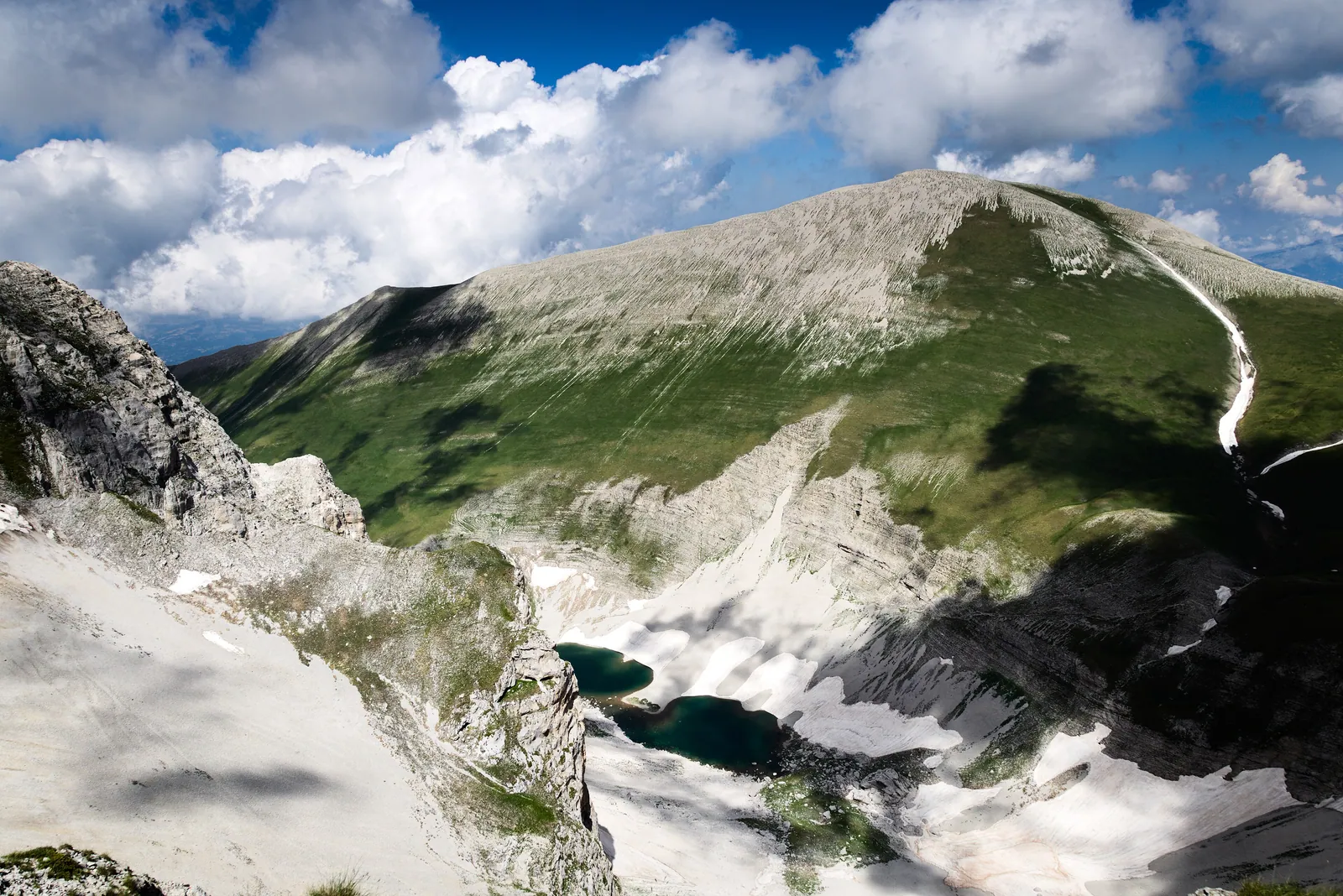
Lago di Pilato (Lake Pilato) is the only natural lake in Le Marche, and it can only be reached on foot. It lies at 1,941 m in a glacial cirque on Monte Vettore, in the municipality of Montemonaco (province of Ascoli Piceno), inside the Sibillini National Park in the Sibillini Mountains. There are three main trails: from Foce di Montemonaco and from Forca di Presta, a mountain pass, on the Marche side, and from Castelluccio di Norcia via Forca Viola on the Umbrian side.
The lake fills the floor of a narrow valley enclosed by steep, sheer rock walls right below the summit of Monte Vettore. When there is plenty of water, the two basins connect and form the shape that earned the lake its nickname, the "lake with glasses" (lago con gli occhiali). With less water, two separate pools remain, like a pair of eyes. Its waters are home to the chirocefalo del Marchesoni (Marchesoni's fairy shrimp), a small red crustacean that swims upside down, belly up, and exists only here. Centuries of stories have gathered around the lake: necromancers who climbed up here to consecrate books of magic, storms summoned by demons, and the body of Pontius Pilate dragged from Rome on a cart pulled by two buffalo.
Before you go
Forecast
- Today9° / 5°0.0 mmCloudy
- Tomorrow10° / 5°5.8 mmLight rain
- Friday7° / 3°25.4 mmHeavy rain
Forecast by MET Norway, updated automatically · license CC BY 4.0
Rules and orders: Park website. Snow and avalanches: Meteomont bulletin.
On the map
Points from the site database. Map © OpenStreetMap contributors · Protomaps.
Where is Lago di Pilato?
Lago di Pilato is in Le Marche, in the territory of Montemonaco, less than a kilometer from the border with Umbria. It sits in a narrow glacial valley north of the main summit of the Vettore massif and is surrounded by the highest peaks of the Sibillini: Monte Vettore (2,476 m), Cima del Redentore (2,448 m), Cima del Lago (2,422 m) and Pizzo del Diavolo (2,410 m).
It is an alpine-type glacial lake, one of the few in the Apennines. It formed behind a dam made by the remains of a moraine, and the valley took its present shape in the Late Pleistocene. The water comes from rain and, above all, from melting snow. The lake has no visible outlet: on its floor there are sinkholes that may be connected to the springs of the Aso river through underground karst channels.
Lago di Pilato is about 130 m wide and 8-9 m deep. The depth was measured in 1990, when a severe drought left the basin completely dry. At its fullest, which happens very rarely, the lake covers 3 hectares. In recent summers the water has often been missing, both because of more frequent droughts and probably because the 2016 earthquake made the ground more permeable. In 2026 the two basins stayed joined from June 4 to July 11, for 37 days: this had not happened for eight years.
How to get to Lago di Pilato
Lago di Pilato can only be reached on foot, starting from one of three places: Foce, a small hamlet of Montemonaco; the Forca di Presta pass, in the municipality of Arquata del Tronto; and Castelluccio di Norcia, on the Umbrian side.
Foce di Montemonaco is the classic starting point. The hamlet is less than 10 km from the historic center of Montemonaco and has several parking lots for cars and campervans. On the Piano della Gardosa, parking is allowed only in the marked areas, driving cars and motorcycles onto the meadows is prohibited, and the local access road may be used only for loading and unloading, with a special pass.
After the earthquake of August 24, 2016, an ordinance of the Comune di Montemonaco closed the trail from Foce. The route partly reopened in July 2017, and an ordinance of May 30, 2018 also reopened the section known as the "Svolte" (the switchbacks). In summer 2026 guided hikes were scheduled from both Foce and Forca Viola. Before setting out, it is still wise to check the ordinances of the local municipalities, which can close trails or roads.
Lago di Pilato hike: trails and routes
From Foce di Montemonaco (trail 151). This is the most direct route. From Foce, walk south for about 45 minutes on a dirt road across the Piano della Gardosa. Where the road ends, a steep path climbs to the left through dense woodland and up a gully in a series of tight hairpin bends, the "Svolte". The trail then enters the lake valley, where the slopes ease and the landscape opens up more and more, all the way to the lake basin. From Foce to the lake takes about 2 and a half to 3 hours; the return follows the same route. The elevation gain is about 1,000 m, for 12-13 km round trip and 5-6 hours of actual walking. The climb is tiring for anyone who is not fit: hiking boots are essential, and trekking poles help. The first section is in the woods, while above the tree line the trail is fully exposed to the sun. Trail markers are sometimes missing, but the path is easy to see.
From Forca di Presta (trail 101). The route climbs toward the summit of Monte Vettore. At the Rifugio Tito Zilioli hut, turn left and descend toward the lake valley on an unmarked path. It is the shortest of the three routes, about 5 km one way, but it is for expert hikers only (EE). Great care is needed on the section called the Roccette, where serious accidents have occurred.
From Castelluccio di Norcia via Forca Viola. Follow trails 553 (Castelluccio-Capanna Ghezzi), 552 (Capanna Ghezzi-Forca Viola), 153 and finally the last section of 151. It is the longest route, but it has fine views over the Piani di Castelluccio, especially between Capanna Ghezzi and Forca Viola, and over the lake valley.
Rules to follow. The valley is protected by the Sibillini National Park:
- swimming or wading is prohibited, even partially, and visitors must stay at least 5 meters from the shore so as not to crush the fairy shrimp eggs laid among the dry rocks;
- if the lake dries up, walking on the lakebed is not allowed;
- dogs are not allowed, not even on a leash, either at the lake or on the trails leading to it;
- bikes, motor vehicles, drones, camping and bivouacking are also prohibited, including in the area of the Rifugio Zilioli;
- leaving the marked path and walking on the scree slopes is prohibited.
Best time to visit Lago di Pilato
Summer is the best time for Lago di Pilato. For much of the year snow covers the lake until early summer, and some snowfields remain all year round. 2026 is a good example: at the end of April the basin was still fully snow-covered, and in mid-May a snowfall had covered it again, leaving only a small lake in the lower basin.
In high summer the problem is the opposite: the water level drops and the lake may be almost or completely dry. In July and August it is best to start very early because of the heat, since the last section is fully exposed to the sun, and to carry enough water. Even in July, patches of ice can remain on the trail in the final section. Guided hikes run from May to September: in the other months snow and ice can make the route impassable.
At altitude the weather changes quickly. A warm layer and a windproof jacket are needed even in August, and the forecast should always be checked before setting out.
What to see near Lago di Pilato
The first thing to look for is the chirocefalo del Marchesoni. It is 9-12 millimeters long, was discovered in the 1950s by researchers from the University of Camerino and is named after Vittorio Marchesoni. Groups of fairy shrimp show up as red patches in the water: binoculars are enough to observe them without approaching the shore. The area is also home to aquatic beetles of the diving beetle family (Dytiscidae), probably of boreo-alpine origin. Higher up fly white-winged snowfinches and red-billed choughs.
Above the lake rises the Gran Gendarme rock, and the valley is closed off by the face of Pizzo del Diavolo. From Forca Viola, trail 2 climbs toward the peaks around the lake: Redentore, Pizzo del Diavolo and Cima del Lago.
The Piano della Gardosa, crossed when starting from Foce, is a large grassland between the Monte Vettore ridge and the Monte Sibilla ridge. From Foce there is also a long, demanding loop that, besides Lago di Pilato, reaches the Laghetto di Palazzo Borghese, a small mountain pond.
In Montemonaco, the Sibyl's Cave Museum, currently closed for restoration, holds the "Gran Pietra" (Great Stone): a slab taken from the lake, engraved with the names of three knights from Spoleto who visited it around 1500. Other bodies of water in the park are listed on the page on the lakes of the Sibillini Mountains in Le Marche, including Lago di Fiastra.
Frequently asked questions
How do you get to Lago di Pilato, and where does the trail start?
Where is Lago di Pilato?
Why is it called Lago di Pilato?
How large and deep is Lago di Pilato?
When is the best time to visit Lago di Pilato?
Where can you stay near Lago di Pilato?
Why does the lake turn red?
Can you swim in Lago di Pilato?
Where can you park for the Lago di Pilato hike?
Nearby
What to see nearby
- 800 m
- 800 m
- 1.0 km
Where to stay
- Bivacco Tito Zilioli, Arquata del TrontoBivouac or unstaffed hut900 m
- AgriMusicismo B&B&B, MontegalloCampground3.9 km
- Casa delle Fate, MontegalloTourist accommodation4.0 km
Where to eat
- Adrenalina, MontegalloClimbing1.9 km
- Classe 62, MontemonacoClimbing2.6 km
- 3.0 km
Straight-line distances.