


Piano Grande di Castelluccio: How to Get There and When to Go
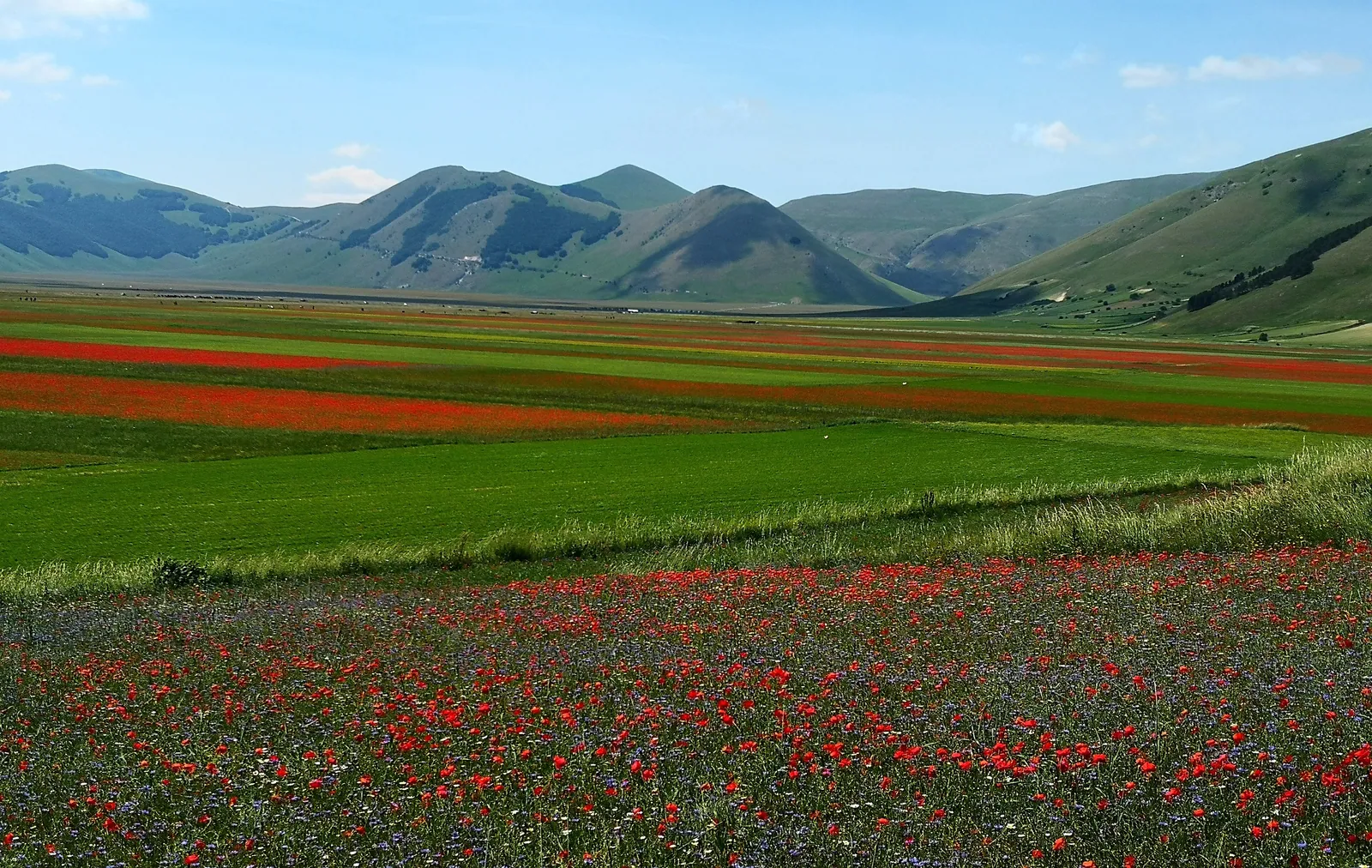
The Piano Grande (Pian Grande) is the largest of the Piani di Castelluccio plains, in the municipality of Norcia, inside the Sibillini National Park in the Sibillini Mountains. Its flat floor is about 7 km long and on average 3 km wide, at an altitude of about 1,250-1,300 m, and it is closed on every side by the ridges of the Sibillini. To the east rises Monte Vettore (2,476 m), the highest peak of the range. On the northern edge, on a hill, stands the village of Castelluccio di Norcia, at 1,452 m. Between late May and mid-July the Piano Grande of Castelluccio is known for its flowering: fields of Castelluccio lentils (IGP) alternate with poppies, cornflowers, daisies, narcissi and violets.
The Piano Grande was once a lake. The basin formed because the rock masses sank while the Vettore ridge was rising. The basin then turned into a marsh, as the peat deposits show, and drained away through karst processes, mainly through the sinkhole of the Fosso dei Mergani. The Piano Grande is considered the largest karst plateau in Italy after the Piana del Fucino. Today it is largely an expanse of meadows and fields, the result of centuries of grazing and farming.
Before you go
Forecast
- Today15° / 9°0.0 mmPartly cloudy
Forecast by MET Norway, updated automatically · license CC BY 4.0
Rules and orders: Park website. Snow and avalanches: Meteomont bulletin.
On the map
Points from the site database. Map © OpenStreetMap contributors · Protomaps.
Where the Piano Grande di Castelluccio Is
The Piano Grande di Castelluccio lies at the eastern tip of Umbria, in the province of Perugia and the municipality of Norcia, on the border with the Marche. It is the largest of the three Piani di Castelluccio. The Pian Piccolo lies below the village. The Pian Perduto is farther north, in the Marche, in the province of Macerata.
To the east the Piano Grande is closed by the Costa del Vettore, a very steep slope that drops about a thousand meters to the plain. The long straight road across the Piano Grande links Castelluccio with Forca Canapine and Norcia. In the southern part of the plain is the Fosso dei Mergani. It looks like a stream fed by a spring, but it is a karst channel that ends in a sinkhole. Rain and snowmelt water end up there, estimated at between 60 and 70 million cubic meters a year. The name Mergani comes from the Latin verb mergo, meaning "to plunge". In spring a marshy area forms around the channel, which dries up almost completely in summer.
How to Get to the Piano Grande di Castelluccio
The Piano Grande can only be reached by private vehicle: no regular public transport line serves the plain. There are two main roads, one from Umbria and one from the Marche.
From Norcia it is about 30 km. Follow the SS 685 and, before the entrance to the Forca Canapine tunnel, take the SP 477. The road climbs to a pass and from there starts to descend into the Piano Grande. From the highest point the whole plain can be seen at a glance, and it is one of the best spots for photographing the flowering.
From the Marche side, take the Salaria (SS 4) to Arquata del Tronto and climb toward Montegallo. After the locality of Pretare, turn left toward Forca di Presta (1,536 m), one of the access points to the Piani. From Forca di Presta the road descends to the Piano Grande, and from there it is about ten minutes by car to Castelluccio.
During the flowering, access is regulated. In 2026 cars could be used freely on weekdays. On four weekends between June and July, however, it was not permitted to drive directly to Castelluccio by car or camper van. On those days there were parking areas at altitude and shuttles from the Umbrian side and the Marche side. The rules are set every year, so check them before setting out.
In winter and early spring the SP 477 can close because of snow, strong wind or avalanches. In 2026 this happened several times, including on the stretch between the Piano Grande and Forca di Presta, which was blocked by avalanches coming down from the Vettore.
Piano Grande di Castelluccio Trails and Hikes
The most classic Piano Grande hike starts from Castelluccio, crosses the Piano Grande diagonally and reaches the Fosso dei Mergani, in the southern part of the plain. It is one of the easiest routes in the area and can be done on foot, by mountain bike or on horseback. The altitude ranges from about 1,257 to 1,418 m, the elevation gain is about 180 m and the difficulty is E (hiking). Times vary a lot depending on pace and stops. From the village square, the track marked with number 60 on the trail map runs down to the plain. From the sinkhole it is possible to continue toward the Casaletto Guglielmi.
A shorter variant reaches the Fosso dei Mergani after about 1.5 km from the start. This stretch is easy and suitable for everyone. Those who want a longer outing can climb toward Costa Sassetti, cross the beech wood of Macchia Carbonara and reach the lifts of Monte Cappelletta (1,654 m), before returning to the channel. In all it is about 8.5 km, taking 4-8 hours. This part of the route is less well marked and suitable only for expert hikers.
Trail E13 also crosses the plain, marked with white and red flags bearing "E13". It is known for its variety of spring flowers. The Grande Anello dei Sibillini, a multi-day loop, also passes through this area, where it coincides with the Sentiero Italia. Many other trails climb toward Monte Vettore and the nearby peaks and show the flowering from above. Higher up, at Forca di Presta, the Sentiero per Tutti (Trail for All) stays above 1,500 m throughout and crosses the pastures between the Piano Grande and the Tronto valley.
A few warnings. There is no shade on the Piano Grande: on sunny days it is best to walk in the first or last hours of the day, and in fog it is better to give up. The lentil fields are cultivated land: walk along their edges, without entering them.
Best Time to Visit the Piano Grande di Castelluccio
The most sought-after period runs from late May to mid-July, the flowering season. The peak usually falls in the last week of June, but it has no fixed date: it depends on the year's rain, temperatures and sowing. In May the yellow of buttercups and the white of narcissi dominate. From June the lentil fields color the Piano Grande pink and violet, while wild flowers keep blooming around the Mergani. Heat and drought can spoil the flowering. In a recent summer the Municipality of Norcia canceled the traffic restrictions because the flowers had not fully developed.
On peak weekends the plain fills with visitors, and those who can choose a weekday. The Piano Grande is worth a visit out of season too. In spring the Fosso dei Mergani collects the meltwater. In fall the beech woods around the plain change color. In winter snow covers the plain and turns it into snowshoeing terrain: the loop between the Piano Grande and the Fosso dei Mergani is almost entirely flat and suitable for children too. In winter, however, possible road closures and temperatures well below freezing must be taken into account.
What to See Near the Piano Grande di Castelluccio
Castelluccio di Norcia looks out over the Piano Grande from its hill. The earthquake of October 30, 2016 destroyed it almost completely. In 2026 the rebuilding is still under way: the houses have not been rebuilt, and the shops and eateries operate in temporary structures. The village will be rebuilt on a large earthquake-resistant platform, which is expected to be completed by the end of 2027.
On the slopes of Poggio di Croce, above the Piano Grande, the Italy-shaped forest can be seen. The conifers were planted in 1961, during the tenth Festa della Montagna, for the hundredth anniversary of the Unification of Italy. The idea came from the Minister of Agriculture, Mariano Rumor. At the base of the forest, a few meters from the road, there is a small chapel.
The Pian Piccolo and the Pian Perduto complete the system of the Piani di Castelluccio. The Pian Perduto is linked to the 1522 war of the Pian Perduto. To the southeast, Forca di Presta is the pass at the foot of the Vettore, on the boundary with the municipality of Arquata del Tronto, and the usual starting point for climbing the mountain. Since the 2016 earthquake, some high trails and access points, especially toward Lago di Pilato, have been subject to ordinances that change over time. Other plains and plateaus of the Sibillini Mountains include the Piani di Ragnolo and the Piano dei Pantani.
Frequently asked questions
How large is the Piano Grande di Castelluccio?
How do you get to the Piano Grande di Castelluccio?
When is the best time to visit the Piano Grande di Castelluccio?
Where can you park for the Piano Grande di Castelluccio during the flowering?
What is the easiest Piano Grande di Castelluccio hike?
Nearby
What to see nearby
- under 100 m
- 700 m
- 700 m
Where to stay
- Casa Vacanze Garbini Annarita, NorciaVacation rental400 m
- Affittacamere San Benedetto, NorciaGuesthouse400 m
- Casa Martino, NorciaGuesthouse400 m
Where to eat
- Nemo, NorciaRestaurant500 m
- Beccofino, NorciaRestaurant600 m
- Negozio della Cioccolateria Vetusta Nursia, NorciaSweets and confectionery600 m
Straight-line distances.